Widespread Fuel Contamination’ Reported At Some Florida Gas Stations As Idalia Looms - Latest Updates On Hurricane Idalia.
Widespread Fuel Contamination’ Reported At Some Florida Gas Stations As Idalia Looms - Latest Updates On Hurricane Idalia.
Tuesday, August 29, 2023.


‘Widespread fuel contamination’ reported at some Florida gas stations as Idalia looms
By
Chris Tisch Times staff
Romy Ellenbogen Times staff
Max Chesnes Times staff
Published Yesterday|Updated Yesterday August 28, 2023
The gas, which was contaminated with diesel fuel, could harm engines or make them inoperable just as Floridians seek gas for evacuations or generators.
Florida officials are warning of a “potentially widespread fuel contamination” that may have resulted in people getting fuel from some Florida gas stations that could harm or disable their engines just as Tropical Storm Idalia may put residents on the road or in search of gas to power their generators.
The Florida Department of Agriculture and Consumer Services issued an alert Sunday afternoon stating that gas that was supplied out of Port Tampa Bay by Citgo had become contaminated because of “human error.”
People who received fuel from more than two dozen gas stations across Florida’s Gulf Coast, including several in the immediate Tampa area, could have contaminated fuel if it was purchased after 10 a.m. Saturday, according to the agency.
Citgo-supplied gas stations as far south as Fort Myers and as north as Brooksville were believed to have received the contaminated fuel, according to the agency.
The alert initially said that Citgo “will not release the list of gas stations that received contaminated fuel” but that state officials knew that fuel from the port “serves gas stations in the greater Tampa region north to Chiefland, and on the west side of Florida south to Naples.”
“Citgo sells gas to BJs, 7-Eleven, and also some unbranded stations,” department officials said in the alert, noting that they “will send a more accurate list as it becomes available.”
The state later released the stations that were believed to have received the contaminated fuel.
The announcement was made soon after Tropical Storm Idalia formed. The storm is expected to become a hurricane later this week and threaten the west coast of Florida, where the contaminated fuel was distributed.
The issue was raised at a news conference Gov. Ron DeSantis held Sunday afternoon to talk about storm preparation.
“It has nothing to do with the storm, but it’s happening right on the eve of the storm,” he said.
DeSantis acknowledged the fuel situation may complicate matters.
”You’re going to have people potentially just stuck on the side of the road, I mean, if you fill up your tank with diesel and then you start driving it, it’s not going to end well,” he said.
Gas that is contaminated with diesel fuel has “the potential of causing engine damage or affecting operability,” the department’s alert states.
“Impacted stations have been asked to stop selling gas until the contaminated fuel is replaced and tanks are cleaned. Once the stations are cleared or have completed a corrective action plan fuel will once again be safe for purchase,” the alert states.
A spokesperson for Port Tampa Bay said Citgo is a “privately-held terminal,” which means the port itself has no oversight over Citgo’s facility, even though it rests within the port’s footprint. That means any details about the “human error” leading to fuel contamination would have to come directly from the company, according to spokesperson Lisa Wolf-Chason.
”They employ their own people, they have their own operators, and they own the land they operate off of,” Wolf-Chason said in a phone interview. “I know this is unfortunate news for Citgo, but we have been working with other fuel operators to make sure they’re prepared for the storm and can help supply the state with fuel.”
State officials opened a hotline to receive complaints from people who believe they bought the bad fuel. People can call 1-800-435-7352 or make a complaint at fdacs.gov.
The state also is “coordinating with petroleum retailers, ports and all additional stakeholders to ensure that this disruption won’t be widespread and that residents can have seamless access to fuel,” the alert states.
The Florida Department of Emergency Management also has “waived size, weight, and hour restrictions to get resources into the state as quickly and efficiently as possible,” the alert states.
The gas stations that are believed to have received the contaminated fuel are:
Big Dan’s Car Wash: 39522 US Highway 19 N, Tarpon Springs (A spokesperson for this location emailed the Times on Sunday night and said none of their fuel had contamination and that they expected to be cleared by the state by end of day Monday).
7-Eleven: 3437 US Highway 19, Holiday
7-Eleven: 13411 Fish Hawk Blvd., Lithia
7-Eleven: 4325 Lee Blvd., Lehigh Acres
7-Eleven: 12750 South Cleveland Ave., Fort Myers
7-Eleven: 290 Lakeland Park Road, Lakeland
7-Eleven: 720 Chiquita Blvd., North Cape Coral
7-Eleven: 2604 Skyline Blvd., Cape Coral
7-Eleven: 940 S Broad St., Brooksville
7-Eleven: 1626 Meadow Road, Lehigh Acres
7-Eleven: 2401 James Redman Parkway, Plant City
7-Eleven: 601 Pine Island Road SW, Cape Coral
7-Eleven: 6050 Dean Dairy Road, Zephyrhills
7-Eleven: 714 Burnt Store Road, Cape Coral
BJ’s Wholesale: 1929 Pine Island Road NE, Cape Coral
BJ’s Wholesale: 9372 Ben C Pratt Six Mile Cypress Pkwy., Fort Myers
BJ’s Wholesale: 13585 NE 86th Path, Lady Lakes
Handy Foods Store #86: 21321 Palm Beach Blvd., Alva
Handy Foods Store #87: 3205 Lee Blvd., Lehigh Acres
Superday CITGO: 1595 S McCall Road, Port Charlotte
Bolton One LLC: 15434 US Highway 19, Hudson
JHW #310 DBA Avenue CITGO: 11867 N Williams St., Dunellon
AL Prime Daytona Beach: 1898 S Clyde Morris Blvd., Daytona Beach
Quick & Easy Stop: 4529 Bee Ridge Road, Sarasota
Palmers Easy Stop: 903 Cattleman Road, Sarasota
Faulkenburg CITGO: 5320 Faulkenburg Road, Tampa
Choice Food & Gas: 310 N Central Ave., Umatilla
2K Express 5: 6202 N 40th St., Tampa
Perfection Station 5: 9931 N Florida Ave., Tampa
'Potentially widespread' gasoline contamination complicates storm prep for many
WFLA News Channel 8 August 28, 2023
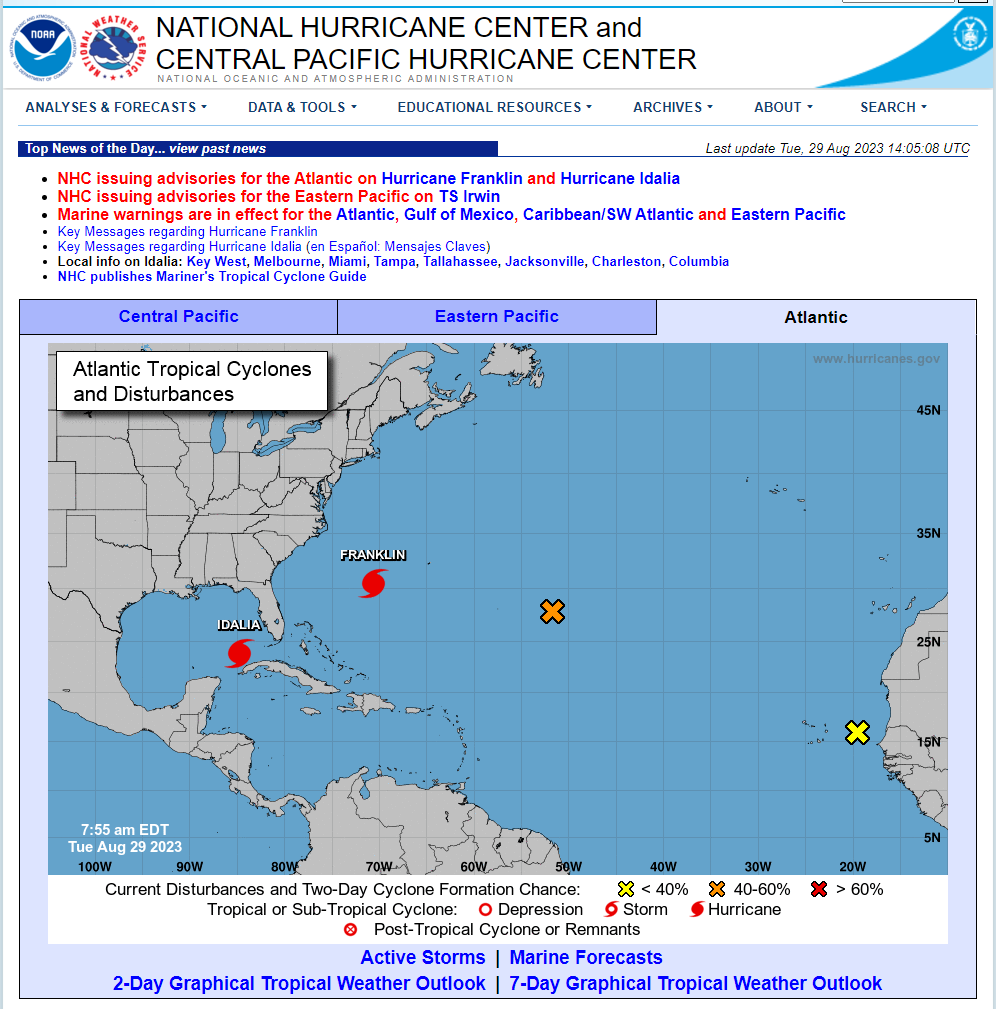
National Hurricane Center Updates On Hurricane Idalia.
NHC issuing advisories for the Atlantic on Hurricane Franklin and Hurricane Idalia
NHC issuing advisories for the Eastern Pacific on TS Irwin
Marine warnings are in effect for the Atlantic, Gulf of Mexico, Caribbean/SW Atlantic and Eastern Pacific
Key Messages regarding Hurricane Idalia (en Español: Mensajes Claves)
Local info on Idalia: Key West, Melbourne, Miami, Tampa, Tallahassee, Jacksonville, Charleston, Columbia
Please click on this link for the latest updated Public Advisory.
000
WTNT35 KNHC 291153
TCPAT5
BULLETIN
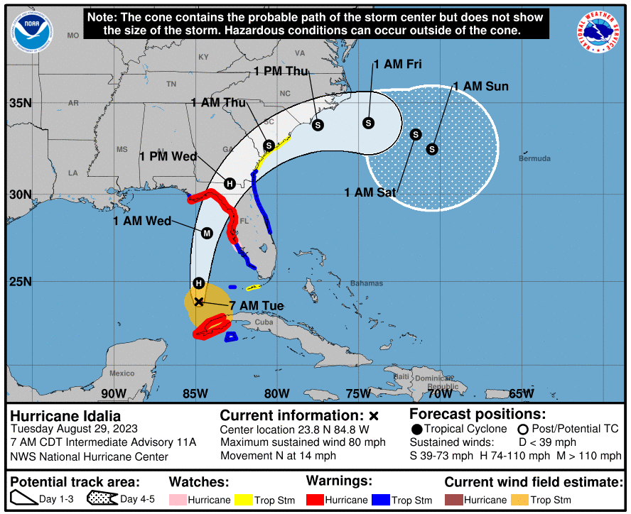
Hurricane Idalia Intermediate Advisory Number 11A
NWS National Hurricane Center Miami FL AL102023
700 AM CDT Tue Aug 29 2023
...NOAA HURRICANE HUNTERS FIND IDALIA STRENGTHENING...
SUMMARY OF 700 AM CDT...1200 UTC...INFORMATION
----------------------------------------------
LOCATION...23.8N 84.8W
ABOUT 135 MI...215 KM WSW OF THE DRY TORTUGAS
ABOUT 320 MI...515 KM SSW OF TAMPA FLORIDA
MAXIMUM SUSTAINED WINDS...80 MPH...130 KM/H
PRESENT MOVEMENT...N OR 005 DEGREES AT 14 MPH...22 KM/H
MINIMUM CENTRAL PRESSURE...977 MB...28.85 INCHES
WATCHES AND WARNINGS
--------------------
CHANGES WITH THIS ADVISORY:
None.
SUMMARY OF WATCHES AND WARNINGS IN EFFECT:
A Storm Surge Warning is in effect for...
* Englewood northward to Indian Pass, including Tampa Bay
A Hurricane Warning is in effect for...
* Cuban province of Pinar del Rio
* Middle of Longboat Key northward to Indian Pass, including Tampa
Bay
A Tropical Storm Warning is in effect for...
* Isle of Youth Cuba
* Dry Tortugas Florida
* Chokoloskee northward to the Middle of Longboat Key
* West of Indian Pass to Mexico Beach
* Sebastian Inlet, Florida to Altamaha Sound, Georgia
A Storm Surge Watch is in effect for...
* Chokoloskee northward to Englewood, including Charlotte Harbour
* Mouth of the St. Mary's River to South Santee River South
Carolina
A Hurricane Watch is in effect for...
* Englewood to the Middle of Longboat Key
A Tropical Storm Watch is in effect for...
* Lower Florida Keys west of the west end of the Seven Mile Bridge
* Altamaha Sound northward to South Santee River South Carolina
A Hurricane Warning means that hurricane conditions are expected
somewhere within the warning area. Preparations to protect life
and property should be rushed to completion.
A Storm Surge Warning means there is a danger of life-threatening
inundation, from rising water moving inland from the coastline,
during the next 36 hours in the indicated locations. For a
depiction of areas at risk, please see the National Weather
Service Storm Surge Watch/Warning Graphic, available at
hurricanes.gov. This is a life-threatening situation. Persons
located within these areas should take all necessary actions to
protect life and property from rising water and the potential for
other dangerous conditions. Promptly follow evacuation and other
instructions from local officials.
A Tropical Storm Warning means that tropical storm conditions are
expected somewhere within the warning area.
A Storm Surge Watch means there is a possibility of life-
threatening inundation, from rising water moving inland from the
coastline, in the indicated locations during the next 48 hours.
For a depiction of areas at risk, please see the National Weather
Service Storm Surge Watch/Warning Graphic, available at
hurricanes.gov.
A Hurricane Watch means that hurricane conditions are possible
within the watch area.
A Tropical Storm Watch means that tropical storm conditions are
possible within the watch area, generally within 48 hours.
Interests elsewhere along the southeastern U.S. coast should
monitor the progress of this system. Additional watches and
warnings along the southeast United States coast will likely be
required later today.
For storm information specific to your area in the United
States, including possible inland watches and warnings, please
monitor products issued by your local National Weather Service
forecast office. For storm information specific to your area
outside of the United States, please monitor products issued by
your national meteorological service.
DISCUSSION AND OUTLOOK
----------------------
At 700 AM CDT (1200 UTC), the center of Hurricane Idalia was located
near latitude 23.8 North, longitude 84.8 West. Idalia is moving
toward the north near 14 mph (22 km/h). A northward motion is
expected today, followed by a faster north-northeast motion later
today and Wednesday. On the forecast track, the center of Idalia is
forecast to move over the eastern Gulf of Mexico today, reach the
Gulf coast of Florida within the Hurricane Warning area on
Wednesday, and move close to the Carolina coastline on Thursday.
Data from a NOAA Hurricane Hunter aircraft indicate that maximum
sustained winds have increased to near 80 mph (130 km/h) with higher
gusts. Rapid intensification is likely through landfall, and Idalia
is forecast to become an extremely dangerous major hurricane before
landfall on Wednesday.
Hurricane-force winds extend outward up to 15 miles (30 km) from
the center and tropical-storm-force winds extend outward up to 160
miles (260 km).
The minimum central pressure based on dropsonde data is 977 mb
(28.85 inches).
HAZARDS AFFECTING LAND
----------------------
Key messages for Idalia can be found in the Tropical Cyclone
Discussion under AWIPS header MIATCDAT5 and WMO header WTNT45 KNHC,
and on the web at hurricanes.gov/text/MIATCDAT5.shtml
STORM SURGE: The combination of a dangerous storm surge and the
tide will cause normally dry areas near the coast to be flooded by
rising waters moving inland from the shoreline. The water could
reach the following heights above ground somewhere in the indicated
areas if the peak surge occurs at the time of high tide...
Aucilla River, FL to Chassahowitzka, FL...8-12 ft
Chassahowitzka, FL to Anclote River, FL...6-9 ft
Ochlockonee River, FL to Aucilla River, FL...5-8 ft
Anclote River, FL to Middle of Longboat Key, FL...4-7 ft
Tampa Bay...4-7 ft
Middle of Longboat Key, FL to Englewood, FL...3-5 ft
Englewood, FL to Chokoloskee, FL...2-4 ft
Charlotte Harbor...2-4 ft
Indian Pass, FL to Ochlockonee River, FL...3-5 ft
Mouth of the St. Mary's River to South Santee, SC...2-4 ft
Chokoloskee, FL to East Cape Sable, FL...1-3 ft
Flagler/Volusia County Line, FL to Mouth of St. Mary's River...1-3
ft
Indian Pass to Mexico Beach...1 to 3 ft.
Florida Keys...1-2 ft
The deepest water will occur along the immediate coast in areas of
onshore winds, where the surge will be accompanied by large and
dangerous waves. Surge-related flooding depends on the relative
timing of the surge and the tidal cycle, and can vary greatly over
short distances. For information specific to your area, please see
products issued by your local National Weather Service forecast
office.
Elevated water levels along the southern coast of Pinar del Rio,
Cuba will gradually subside today.
WIND: Hurricane and tropical storm conditions are expected within
the warning areas in western Cuba through this morning.
Hurricane conditions are expected within the hurricane warning area
in Florida by late today or Wednesday, with tropical storm
conditions beginning today.
Tropical storm conditions are expected in the Dry Tortugas soon and
within the tropical storm warning area along the Florida Gulf coast
and the Florida west coast later today.
Tropical storm conditions are expected to begin on Wednesday in the
warning area along the east coast of Florida and South Carolina
Tropical storm conditions are possible along the southeast U.S.
coast within the southern portions of the watch area by early
Wednesday.
RAINFALL: Idalia is expected to produce the following rainfall
amounts:
Western Cuba: 4 to 7 inches, with isolated higher totals of 10
inches.
Portions of the west coast of Florida, the Florida Panhandle,
southeast Georgia and the eastern Carolinas: 4 to 8 inches from
today into Thursday. Isolated higher totals of 12 inches possible,
primarily near landfall in northern Florida.
This rainfall may lead to flash and urban flooding, and landslides
across western Cuba.
Areas of flash and urban flooding, some of which may be locally
significant, are expected across portions of the west coast of
Florida, the Florida Panhandle, and southern Georgia today into
Wednesday, spreading into portions of the eastern Carolinas
Wednesday into Thursday.
SURF: Swells generated by Idalia are affecting portions of the
southern coast of Cuba and eastern Yucatan. These swells will
spread northward along the eastern United States Gulf Coast during
the next day or two. These swells are likely to cause life-
threatening surf and rip current conditions. Please consult
products from your local weather office.
TORNADOES: A few tornadoes will be possible later day along the
west central Florida coast. The tornado threat will spread
northward into the Florida Big Bend by tonight.
NEXT ADVISORY
-------------
Next complete advisory at 1000 AM CDT.
$$
Forecaster BergThe Truth Is Stranger Than Fiction!
You Want The Truth, You Can’t Handle The Truth!
There Are None So Blind As Those Who "Will - Not" To See!
You Can’t Wake Up - If You Don’t Know That You Are Asleep!