


On Monday I drove up to Ruidoso, New Mexico to shoot some video and take photos of the ongoing South Fork, and Salt Forest Fires. My photo above is smoke streaming eastward from the fires. I was on US Hwy 70 about 20 miles west of Roswell. The fires were to the west of me some 50 miles away. This is all smoke from the fires not clouds.
Ruidoso is a mountain community located in the south-central mountains (Sacramento mountains) west of Roswell, New Mexico in Lincoln County. It is a haven and tourist community for many folks from Texas, Oklahoma, and Louisiana, not counting those of us here in New Mexico. Situated at 7,000’ in the cool pines it is a bustling resort town. Ski Apache at the base of 12,003’ Sierra Blanca Peak to the west of Ruidoso is a favorite ski resort in the winter.

Map above is courtesy of Bad Hoss Map Company in Ruidoso, New Mexico.
The South Fork fire was discovered at 9 AM MDT, on Monday,, June 17th just west of Ruidoso. The Salt fire developed later in the day and to the south of the South Fork fire. As of last night the South Fork fire had burned at least 15, 276 acres of forest. The Salf fire had burned some 5,557 acres of forest on the Mescalero Apache Indian Reservation. Our governor has declared a state of emergency because of the fires.
Ruidoso has a normal population of around 8,000 people but this swells up by the tens of thousands in the winter and summer. Ruidoso Downs adjoining Ruidoso has a normal population of a couple of thousand people. And like Ruidoso its population also explodes during the tourist season in the summer and winter.
All of Ruidoso and Ruidoso Downs have been evacuated. The official statement last night that 8,000 people had fled to safety. But this is way underestimated in my opinion and may be closer to 20,000 or more because of all of the tourists that were in the area when the fires broke out. I don’t know exactly how many people fled and there is now way of knowing that for sure right now.

I shot this photo near Picacho, west of Hondo, on US Hwy 70. All of this is smoke!
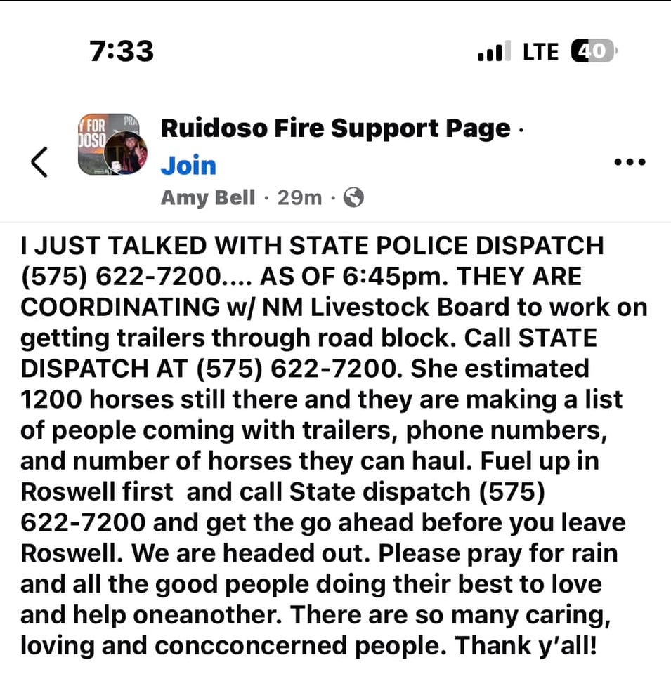
Nearby Ruidoso Downs is famous for its horse racing. A race against time to save some 1,200 horses in Ruidoso Downs is underway.
Tragically at least one death has been reported. Some 1,400 structures have burned to the ground and this may go up. Making this fire the most destructive in New Mexico’s history.
As of last night both fires were 0% contained. There has been a massive response from the US Forest Service, BLM, local and state fire fighting agencies. All local communications have been lost to the public in the fire zone. There are a lot of people reported to be unaccounted for or missing. This does not necessarily mean that they died in the fire. Some people refused to evacuate and leave their homes and properties. And it has been reported that they were sleeping in the vehicles in parking lots in town.
The number of pets and livestock that may have been left behind is also unknown. There has been a frantic effort by owners and locals to save as many as possible. No doubt the local wildlife has also been decimated. Such as deer, turkey, bear, trout, and numerous types of native birds.
The fires are still burning uncontained as of this morning and local law enforcement and officials still have all access to the area shut down. So its not fully known yet just how devastating these fires have been…at least to the public.
What started both fires is unknown. There was no thunderstorms activity in the area Monday when the fires erupted. Naturally the rumor mill is running amok with all kinds of speculation. Including comments and questions as whether or not these fires were started by Direct Energy Weapons (DEW) intentionally. I have seen no concrete proof or evidence of this so far. However if you look closely at the videos and photos you can clearly see that these were very hot fires. Vehicles have been partially melted while nearby pine trees were left untouched. Was this another Lahaina, Maui type attack? I don’t know that answer at this point but there are a lot of questions being raised. See my stacks on the Maui fires last year below.
What Happened In Maui? August 15, 2023
Who Is Lying About The Maui Firestorm? August 18, 2023
Something Is Not Right - Two Weeks Later & We Still Have More Questions Than Answers. Latest On Tropical Storm Idalia. August 28, 2023
Where Are The 2,000+ Missing Children? - Hawaiian Electric Vehemently Denies Causing The Recent Fires That Engulfed Parts Of Maui August 29, 2023
Maui Fires and Directed Energy Weapons September 1, 2023
Lahaina Reopens and New Questions Arise. Saturday, November 4, 2023
Lahaina, Maui - Front Street Driving Tour - 8 Months after the Fire - And Still More Questions Than Answers! April 3, 2024
Don’t forget that the Ruidoso area just finished dealing with another large forest fire “The Blue 2 Fire Update - June 12, 2024”. It broke out on May 16th 8 miles north of Ruidoso and burned 7,532 acres. It was believed to be lightning caused however many have disputed this. The US Forest Service let that fire burn in the White Mountain Wilderness area for days before trying to extinguish it which enraged the local population in the Ruidoso area.
That fire mostly burned over the area that was devastated by the Little Bear Fire in June of 2012. That fire started on June 4, 2012 and burned 44,340 acres. 452 structures were burned in that fire including 242 homes.
Ruidoso also experienced the McBride Fire that started on April 12, 2022 and burned 6,159 acres. Two people lost their lives in that fire. 207 structures were destroyed. There have been other fires in the area in the past 20 years.


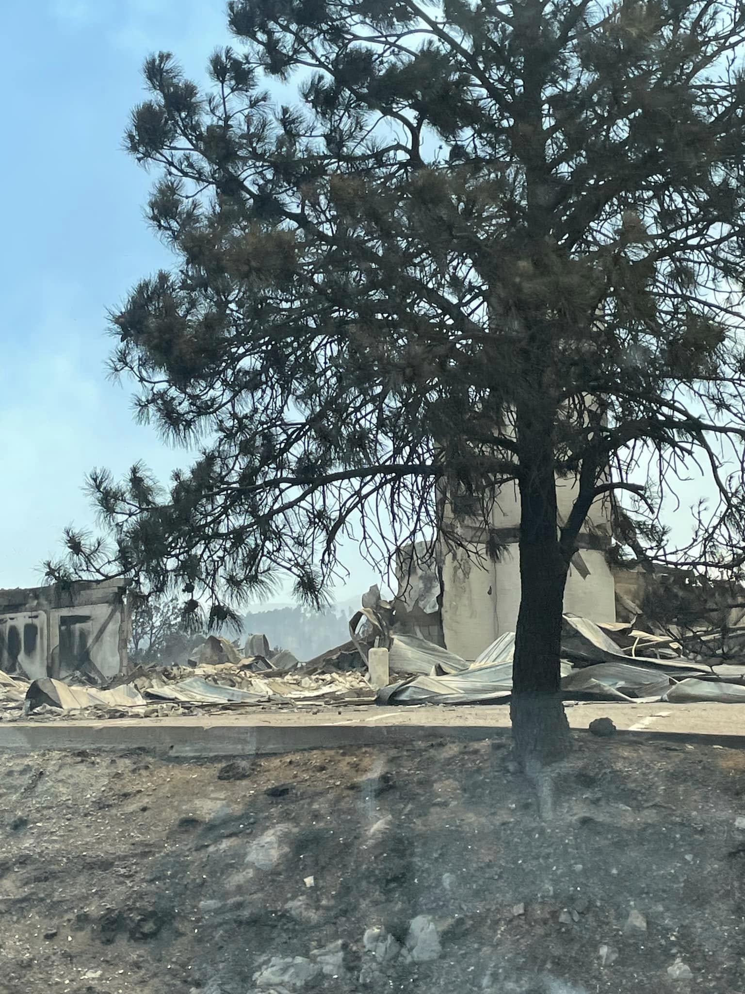
Photos are courtesy of Justin Powell the Dexter, New Mexico Fire Chief.
South Fork Fire continues to burn near Ruidoso. Here's what the fire looks like in NM
Aaron A. Bedoya El Paso Times Published 10:33 AM MT June 18, 2024 | Updated 11:38 MT June 18, 2024
The South Fork Fire and Salt Fire are active wildfires that were discovered on Monday, June 17, on the Mescalero Reservation west of the Village of Ruidoso.


Photos are courtesy of Kaylee Greenlee Beal, REUTERS.
Multiple Hotshots Lose Their Homes While Fighting The South Fork Fire In New Mexico.
THE HOTSHOT WAKE UP JUN 19, 2024
As I discussed on the show today, more than 500 homes, businesses, and structures were burned down after the South Fork Fire swept through Ruidoso, New Mexico, last night. Some of those homes belonged to firefighters on the Smokey Bear Hotshots.
Multiple crewmembers lost their homes while they were doing what they could to slow down the fire’s progression.
A fundraiser has been set up by a friend of the crewmembers and has asked if I would pass this along:

Will The Situation Go From Bad To Worse?

National Blend Of Models (NBM) total rainfall forecast today through Saturday.
National Weather Service Albuquerque Home Page - National Weather Service El Paso Home Page.

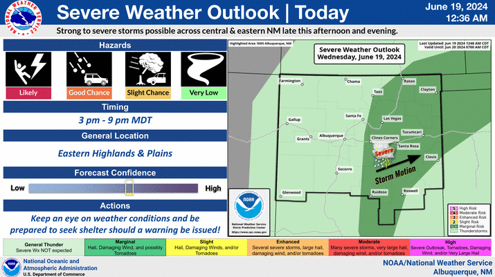


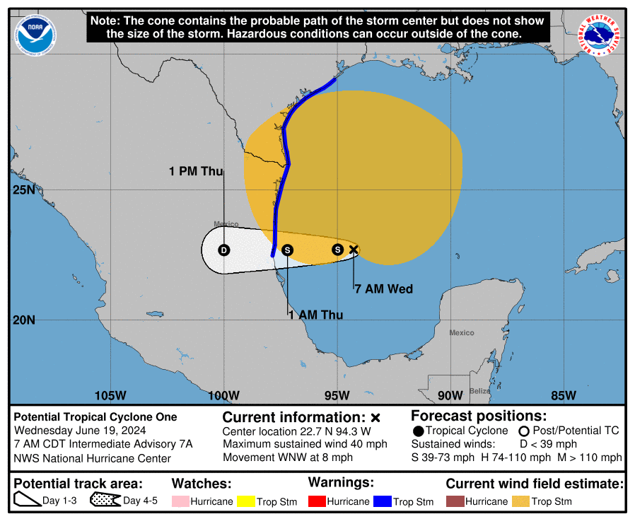
As bad as these fires have been the situation has the potential to become even more devastating today into the weekend. Tropical Storm Alberto is forecast to move waterward into Mexico south of Brownsville Texas. The remnant moisture from this storm is then forecast to spread northwestward into West Texas and New Mexico Thursday into the weekend. This as a cold front drops southward through the state today into tonight.
We are currently in severe to extreme drought conditions in New Mexico and the moisture from these two systems is forecast to bring badly needed beneficial rainfall to the area over the coming days.
However there are great concerns that heavy rain from thunderstorms this afternoon into the weekend may cause life threatening devastating flash flooding on these burn scars. Debris flows and mudflows rushing down the Bonito and Rio Ruidoso rivers as well as normally dry arroyos in the area would only add to the devastation. Any thunderstorms that repeat or train over the same locations will only add to the potential for flash flooding.
A Flash Flood Watch is in effect for the Ruidoso area from this afternoon through tonight. Additional Flash Flood Watches and Warnings are possible into the weekend.
Understand that our local National Weather Service Offices have warned of flash flooding in and near burn scar areas in the past for as little as .25” to .50” of rainfall. It is possible that 1” to 3” of rain could fall today into the weekend. Ash from forest fires becomes silica in nature and as most as slick as ice. So any rain that falls will quickly run off and not soak into the ground. Not to mention the tremendous amount of debris and mud that will accompany any flooding. Lightning strikes and erratic thunderstorm wind gusts will also aggravate the situation. Nothing is set in stone as far as just how rain falls and to what extent it will affect the Ruidoso area. So if you live in this area stay up to date with all of our local weather forecasts today into the weekend.
I am not into “cray or nonsense” but the people of Ruidoso and all of us deserve the truth about what is really going on with these destructive fires. The Lahaina fire is a prime example. By the way we still haven’t been told what happened to those 2,000 kids that were reported missing. The Ruidoso community has been devastated and it will take years to recover. The emotional trauma and stress to those affected is off the scale.
Are weather weapons being used against us? I don’t know but something feels wrong about this!
The Truth Is Stranger Than Fiction!
You Want The Truth, You Can’t Handle The Truth!
There Are None So Blind As Those Who "Will - Not" To See!
You Can’t Wake Up - If You Don’t Know That You Are Asleep!

Share this post