


Not all of Ruidoso has burned. Most of the community didn’t burn and the same is true for Ruidoso Downs. My intention is not to in any way minimize the devastation that has already occurred but to put things into perspective. Officials still do not have a clear precise count on the number of homes and structures lost to the fires. At last count that was still standing at approximately 1,400. So far over 23,000 acres have burned with 0% containment on the fires.
Tragically 2 people have been killed in Ruidoso by the fires. A number of people remain unaccounted for and this is believed to be due primarily due to the loss of communications in the local area. Search and rescue dogs are being brought in to help find any missing persons who may have died in the fires.
Officials are reporting that around one 100 people refused to evacuate and remain in Ruidoso. All-access to Ruidoso and Ruidoso Downs has been shut down by Law Enforcement. Not even the media is being allowed in now. This is because of the dangers from the ongoing fires, fire-fighting efforts, and the continued threat of catastrophic flash flooding.
Officials are saying that it could be a week or more before local residents are allowed back into Ruidoso and Ruidoso Downs. Many are outraged over this because most of them still don’t know the status of their homes, properties, and businesses. Thousands of local residents are being sheltered across southeastern New Mexico. The local and state outpouring of support and help in their time of need has been tremendous. Many fled for their lives with only what they could quickly gather up and take with them. Not all of their pets, livestock, and animals were saved or taken with them.
The emotional pain and heartache is immeasurable. The financial losses to these two communities will no doubt be in the millions if not more. Don’t forget about their losses from the Blue 2 fire which occurred a couple of weeks ago which adds to the misery of the situation.
KRQE Jun 20, 2024
Brothers, friends stranded amid South Fork and Salt fires, flash floods
KOAT Jun 20, 2024
Brothers, friends stranded amid South Fork and Salt fires, flash floods
Latest on Ruidoso fires: June 21, 2024 (AM)
KOB 4 June 21, 2024
Here is the latest on the wildfires that have scorched around a total of 24,000 acres and claimed two lives in the Ruidoso area. Story: https://www.kob.com/new-mexico/latest...
Inn of Mountain Gods on Facebook.

Threat For Catastrophic Life-Threatening Flash Flooding Today Into Tonight!
A tropical airmass is in place over New Mexico which is the remnant moisture from former Tropical Storm Alberto. A Flood Watch has been issued for the northern and southern Sacramento mountains for today into this evening. Any additional rainfall that occurs especially from thunderstorms will cause flash flooding. Heavy rainfall to very heavy rainfall produced by thunderstorms with totals of an inch or more will lead to catastrophic life-threatening flash flooding in the Ruidoso area. Mudslides and debris flows will add to the danger.
Albuquerque National Weather Service Forecast for Ruidoso.

Village of Ruidoso on Facebook.

Albuquerque National Weather Service Office Web Page.

Flood Watch - Click on this link for updated information.
Flood Watch
National Weather Service Albuquerque NM
414 AM MDT Fri Jun 21 2024
.Thunderstorm coverage and rainfall intensity will continue to
decrease through the pre-dawn hours, so the Flood Watch that was in
effect until 6 AM MDT this morning for portions of west central and
northwest New Mexico, as well as parts of the central mountain
chain, has been cancelled. A disturbance passing to the north of
New Mexico will draw even richer subtropical moisture northward over
New Mexico this afternoon and tonight, so another Flood Watch for
flash flooding is now being issued for west central and northwest
areas for this afternoon through tonight, and for recent burn scars
along the central mountain chain for this afternoon and evening.
NMZ214-215-226-229-212200-
/O.CAN.KABQ.FA.A.0004.000000T0000Z-240621T1200Z/
/O.NEW.KABQ.FA.A.0005.240621T1800Z-240622T0600Z/
/00000.0.ER.000000T0000Z.000000T0000Z.000000T0000Z.OO/
Southern Sangre de Cristo Mountains-East Slopes Sangre de Cristo
Mountains-South Central Mountains-Northeast Highlands-
414 AM MDT Fri Jun 21 2024
...FLOOD WATCH IS CANCELLED...
The Flash Flood Watch is cancelled for portions of central, north
central, and northeast New Mexico, including the following areas, in
central New Mexico, South Central Mountains. In north central New
Mexico, East Slopes Sangre de Cristo Mountains and Southern Sangre
de Cristo Mountains. In northeast New Mexico, Northeast Highlands.
Flash flooding is no longer expected to pose a threat this morning.
Please continue to heed any remaining road closures.
&&
...FLOOD WATCH IN EFFECT FROM NOON MDT TODAY THROUGH THIS EVENING...
* WHAT...Flash flooding caused by excessive rainfall is possible.
* WHERE...Portions of central, north central, and northeast New
Mexico, including the following areas, in central New Mexico,
South Central Mountains. In north central New Mexico, East Slopes
Sangre de Cristo Mountains and Southern Sangre de Cristo
Mountains. In northeast New Mexico, Northeast Highlands.
* WHEN...From noon MDT today through this evening.
* IMPACTS...Excessive runoff may result in flooding of rivers,
creeks, streams, and other low-lying and flood-prone locations.
* ADDITIONAL DETAILS...
- Numerous showers and thunderstorms will develop this
afternoon and evening. Some storms will produce torrential
rainfall at rates over one inch per half hour. Rapid runoff
will quickly produce flash flooding, especially below recent
burn scars and in locations where the ground is already
saturated from recent heavy rainfall.
- http://www.weather.gov/safety/flood
PRECAUTIONARY/PREPAREDNESS ACTIONS...
You should monitor later forecasts and be prepared to take action
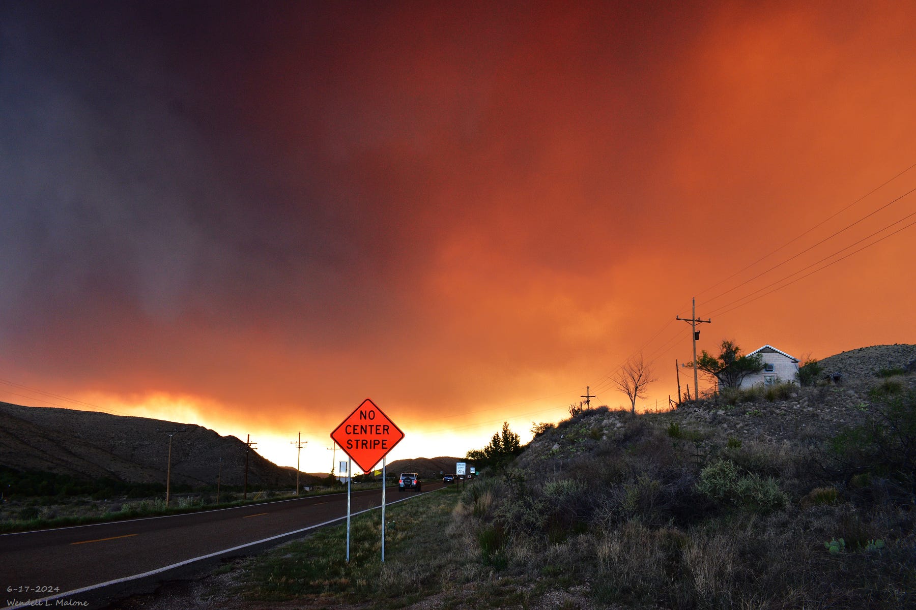
should Flash Flood Warnings be issued.Devastating Flash Flooding Occurred Wednesday Afternoon And Evening.
A supercell thunderstorm developed rapidly over the northern sections of Ruidoso Wednesday at midday. This severe thunderstorm remained nearly stationary, then began a slow drift to the east. It produced ping pong ball to tennis ball size hail and nearly 4 inches of rain in about 30 minutes.
Flash flooding ensued afterward along the Bonito River near Bonito Lake and along the Rio Ruidoso River in Ruidoso, and eastward to just west of Roswell. A max crest of flood waters measured at 8.36’ at the Hollywood flood gauge in southeast Ruidoso was noted. Keep in mind that the Rio Ruidoso, the Rio Hondo, and the Rio Bonito rivers are normally trickling small streams usually no more than a few feet or yards wide and deep. Several high-water rescues were performed for people caught in flood waters.
Evacuations order for flash flood emergency in Ruidoso area
KOAT June 19, 2024
MRMS 48-Hour Estimated Rainfall Totals In The Ruidoso, New Mexico Area As of 8 AM MDT Friday, June 21, 2024. Nearly 4” of rain fell just northwest and northeast of Ruidoso. Most of it fell in about 30 minutes.

Reported New Mexico Mesowest 48-Hour Storm Total Rainfall Amounts.

National Water Prediction Service - An 8.36’ floodwater crest was recorded on the Rio Ruidoso River Wednesday afternoon June 19th, 2024.
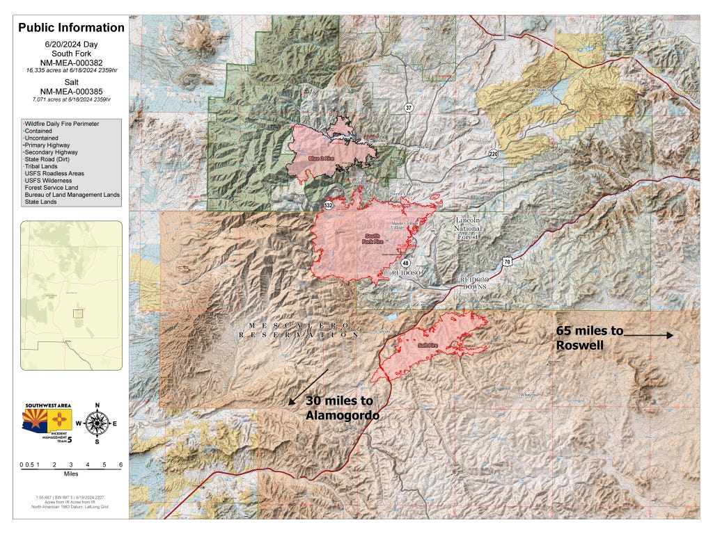
Locations That Have Burned As of Thursday, June 20, 2024.

Map below is courtesy of Bad Hoss Map Company In Ruidoso via Facebook.
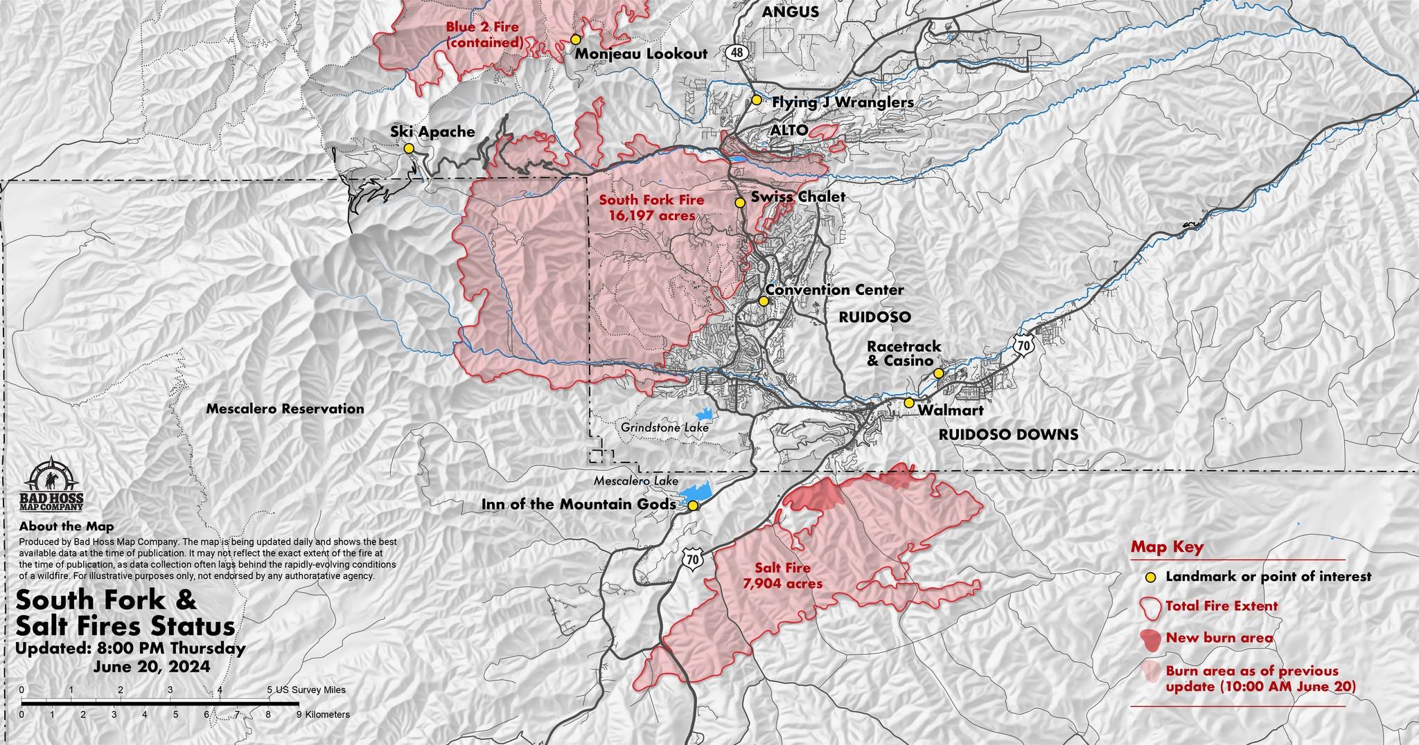

South Fork and Salt Fire Update 6/20/24
JUNE 20, 2024 BY GDUCKER 0 COMMENTS
Acres: South Fork – 16,335; Salt – 7,071
Start Date: June 17, 2024
Location: Ruidoso, NM
Personnel: 824
Containment: 0%
Fuels: mixed conifer, grass, pine/juniper
Resources: Crews, heavy equipment, engines, helicopters and air tankers.
Highlights: A community meeting is scheduled for 5 pm, Thursday, June 20, 2024. All community members are welcome to join via https://www.facebook.com/SWIMT5. Please note, a Facebook account is not needed to participate in the live stream.
Fire Activity: Wednesday, the South Fork Fire experienced active fire behavior through the early part of the day until storms moved into the fire area. Firefighters observed torching trees, uphill runs where wind and terrain aligned and short-range spotting across the South Fork and Salt fires, including within the dead/down fuels of the 2012 Little Bear Fire. In addition to responding to and catching several spot fires yesterday, firefighters worked to secure a portion of the South Fork eastern perimeter from Cedar Creek to eagle Creek (~3 miles) and the south side from Cedar Creek to Flume Canyon.
The north and eastern sides of the South Fork Fire remain the focus for today’s operations, including North Fork and South Fork of Eagle Creek, and along the Rio Ruidoso. Crews will continue constructing firelines to prevent further fire growth, while continuing to protect homes, properties, and critical infrastructure. Ground and aerial ignitions may be used where needed to strengthen protection of values at risk and burn out fuels between constructed firelines and the main fire.
Weather: On Wednesday, the South Fork and Salt fires received varying amounts of rain. The highest rainfall recorded was 1.62” along Skyline Ridge near the Monjeau Fire Lookout on the northern side of the South Fork Fire, while rainfall on the Salt Fire measured .05”. Thursday’s incoming weather will produce clouds, cooler temperatures (68-75 degrees) and higher day/night relative humidity. Storms will likely develop over the lower east slopes of the Sacramento Mountains in the afternoon and into the early evening, producing 20-30mph gusts. Heavy rain, flash floods and debris flows are a potential risk from these storms through the week.
Smoke: Smoke will continue to be observed across both the South Fork and Salt fires today. Individuals sensitive to smoke should take precautions and use the New Mexico Department of Health 5-3-1 Visibility Method to determine if it’s safe to be outside. For more information visit Air Quality: https://nmtracking.doh.nm.gov/environment/air/FireAndSmoke.html
Evacuations: A State of Emergency for the Mescalero Apache Reservation has been implemented by the Tribal Council. Evacuations remain in-place. Village of Ruidoso and City of Ruidoso Downs are in “GO” evacuation status. Road closures are also in effect. Numerous additional evacuation orders have been issued including Fantasy Lane, Summit area, Botella Road, Snow Springs, Fence Canyon, Whitetail, and Chihuahua Well. Please stay out of the fire area to allow firefighters safe access into the area and allow them to work safely. There are hazards in the area including fire weakened trees, downed power lines, and potential for exposed gas lines.
Road and trail closures are in effect throughout the fire area. Both Highway 48 and Highway 70 at
Apache Summit are closed; the open evacuation route is Highway 70 to Roswell. State Hwy 48 is closed from Alpine Village/University to State Hwy 220. US 70 is closed from mm 249 (intersection NM 244), 4 miles east of Mescalero, to mm 258, 2 miles east of Carrizo (https://www.ruidoso-nm.gov/south-fork-fire).
Closures: A Temporary Flight Restriction (TFR) is also in place over the fire area. Visit
https://www.tfr.faa.gov
for more information. Drone flights are also prohibited within this area. If you fly, we may have to ground our air resources.
More information: Inciweb: https://inciweb.wildfire.gov/incident-information/nmmea-south-fork-and-salt
Public Information Line:575-323-8258
Media Information Line: 575-323-8053
Phone Line Hours: 8 am – 8 pm
Email: 2024.southfork@firenet.gov
The Truth Is Stranger Than Fiction!
You Want The Truth, You Can’t Handle The Truth!
There Are None So Blind As Those Who "Will - Not" To See!
You Can’t Wake Up - If You Don’t Know That You Are Asleep!

Share this post